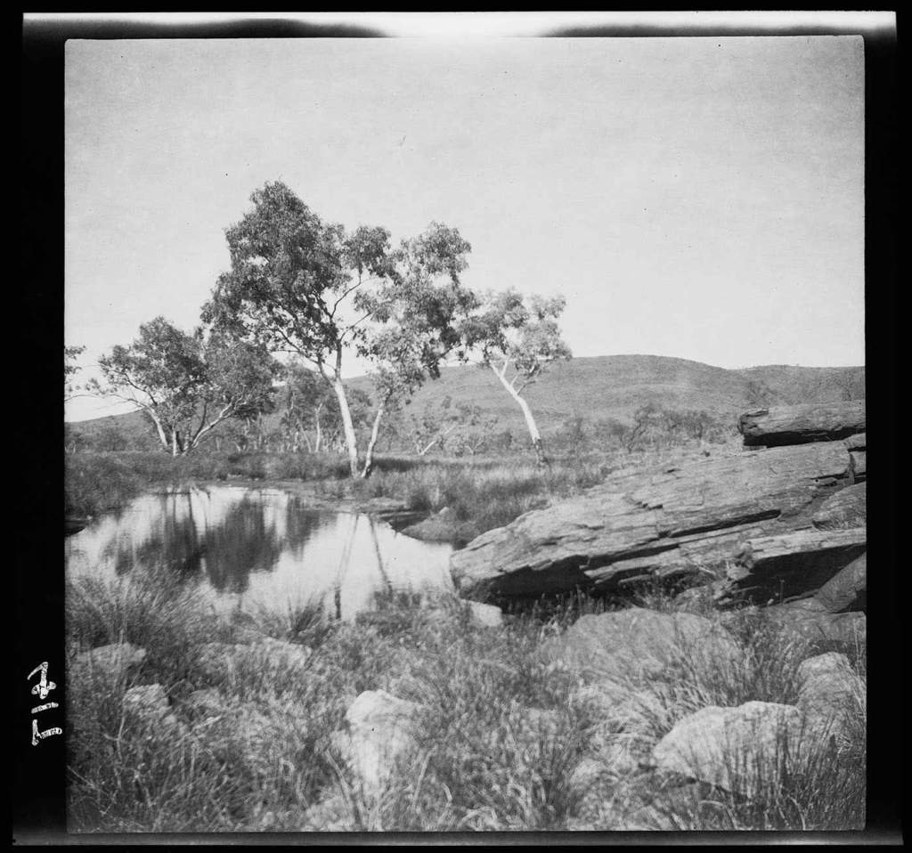
Three years have passed since the 2018 camel trek from Umberatana to Mt Hopeless. In early 2021 we decided to undertake another camel trek, this time to go east from Blinman through the Flinders Ranges via Chambers Gorge then follow Chambers Creek to Lake Frome.
Early in 2021 I had come across some historical material about E. C. Frome, South Australia’s third Surveyor-General. Frome had succeeded Colonel William Light as Surveyor General of the newly established colony of South Australia, and in 1841 he surveyed large areas of the colony, including mapping and recording new territory around Orrorro, north of the newly established city of Adelaide. In 1843 he explored the eastern flank of the Flinders Ranges as far as Mt McKinley (which he mistook for Mt Serle that had been named by E. J Eyre in 1839-40) in the Vulkathunha-Gammon Ranges National Park.
Frome was mapping the country looking for permanent water that the pastoralists needed to establish their sheep runs. In doing so he saw the eastern plains up to Mt Hopeless and Lake Frome which he described: ‘a more barren sterile country could not be imagined.’ The land eastwards of the Flinders Ranges simply was not suitable for agriculture or pastoralism.
Frome made a water colour of these plains in 1843, which he entitled ‘First view of the salt desert–called Lake Torrens’:
The salt lake is now called Lake Frome. Lake Torrens is on the western side of the Flinders Ranges.
The reason for the misnaming is that three years earlier (1840-41) Edward Eyre had explored north and west of the Flinders Ranges, and after sighting several salt lakes concluded that a continuous horse-shaped Lake Torrens created a barrier to the north of the continent.
In his journal Eyre describes the extent of Lake Torrens as he sees it, stretching in an arc from the west around to the east and with the surface too soft and yielding for any attempt to cross. His expectations of a route to the north and the possible discoveries of pastoral land, flowing rivers and lakes of fresh water, were barred by the appearance of an enormous horseshoe shaped salt lake.
Finally we made it to Mt Hopeless. It was just a morning walk across a gibber plain from the over night camp on the dusty clay plain. 12 days walking with the camels had come to an end.
The snapshot below is looking south across the camel train to where we had walked. It is from the top of Mt Hopeless and it was taken just after midday.
The light was bad at midday so I decided to return in the late afternoon. This picture is looking north to Lake Callabonne from the top of Mt Hopeless. Flinders and Beyond did offer another leg of the trek that started from Mt Hopeless and went north to Cooper Creek (I’m not quite sure of the end point), but there were too few takers to make it viable. It sounded pretty good to me: the creek is the second longest inland river system in Australia. It is part of the Lake Eyre basin and the Channel Country.
I have been reading some books on colonial photography in South Australia to look for some 19th century photographs of the northern Flinders Ranges and northern South Australia. Even though photography in the field would have been very difficult with the wet plate process at the time, I was expecting to find some examples of colonial expedition photography as the dry-plate process was available in the colony by the early 1880s. My initial understanding was that photographers had accompanied some of the inland expeditions to northern South Australia and across to western Australia in the 1880s-1890s. Cameras, for instance, were used on David Lindsay’s 1885-6 exploring expedition from Adelaide to Port Darwin by Lieutenant Hermann Dittrich, the German naturalist/botanist was on the expedition on the recommendation of Baron Ferdinand von Mueller. Unfortunately, the dry plate glass negatives were severely overexposed and useless.
I started with A Century in Focus: South Australian Photographs 1940s-1940 by the Art Gallery of South of South Australia (AGSA) — the most obvious place. It was a disappointment. For instance, The Elder Scientific Exploration Expedition, 1891–92 under David Lindsay, which left from the northern railway terminus (near Andamooka) in South Australia and traveled across the Great Victoria Desert to Western Australia, made substantial use of photography. Yet Dr Frederick John Elliot, the expedition’s medical officer and photographer, is not mentioned in A Century in Focus.
It is a puzzle that the AGSA missed this body of expedition photography. Was it a lack of research? Were the researchers content to work only from their own collection?
European exploration of South Australia was effectively complete by the time of the Elder Scientific Exploration Expedition of 1891–92. So what about photography made on earlier expedition in the northern Flinders Ranges and beyond?
Day 11 was a 15 kilometre walk on a mild, dry winters day through Murnpeowie Station, over stony plains, lunch at Mundawatana Creek, then across a gibber plain, through the dog fence to a camp on a clay plain. Most of the trees were confined to creek beds and run-off areas. As we walked through the territory, which was a long way from the benign, pristine and photogenic landscapes and iconic vistas of the tourist brochures — the Outback — I wondered about the absence of photographers in the explorer’s expeditions to Lake Eyre and the northern Flinders Ranges and Central Australia until Francis Gillen and Baldwin Spencer in the late 1890s. Maps, journals and sketches filled the space of photography’s absence in exploration to discover land of economic value was crucial to the well-being of colonial Australia.
Why was photography absent in colonial exploration? Did the interior of South Australia lack pictorial interest for photographers? Were the explorers more interested in their journey and not the landscape they were traveling through? Did the explorers hold that photography was not really needed? The abandoned Elder Scientific Exploration of 1891-2 under David Lindsay appears to be the first to successfully make use of photography. Dr Frederick John Elliot, the photographer on that expedition, does not rate a mention in A Century in Focus: South Australian Photography 1840’s-1940s. Nor is the expedition mentioned in this text.
firewood
The Pastoral Land Management and Conservation Act 1989 limits land uses on pastoral leaseholds almost solely to grazing specified stock on native pastures. The rangeland at Murnpeowie Station over which we walking was unsuitable for agriculture. How sustainable is pastoralism as a land use—sheep and cattle grazing on natural vegetation— in this arid zone? The leased land that I was walking over looked denuded, eroded and degraded from drought and over-stocking, and it had little protective plant cover.
This is a culturally encoded landscape. The pioneer legend is about the battle that the explorers fought and won over great natural difficulties and obstacles, whose triumph resulted in permanent occupation and settlement of a vast continent through subduing the land and battling the elements by those pastoralists who first “settled” the land. The legend celebrates the courage, enterprise, hard work and perseverance of the explorers pastoralists, and then the farmers. Settlement was held to be the necessary and benevolent introduction of British civilization.
The pioneer legend overlooks two significant aspect of the colonial history. Firstly, there is the long history of the environmental degradation of the land from 100 years of pastoralism’s bad management practices since European settlement. Habitat change and the introduction of feral predators and herbivores resulted in medium sized mammal species (bilbies) becoming either endangered or extinct.
polypipe, Murnpeowie Station
Secondly, the Aboriginal people’s presence in the legend is one of adversaries who had to be battled and put in their place in the process of subduing the land. The aboriginal perspective on the frontier violence had no place in the pioneer legend. The legend, which mythologized the violent frontier, indicates the then cultural supremacy of the pastoral industry in South Australia.
Presumably, as the Adnyamathanha people were dispossessed from their traditional land many were able to retreat to the ranges, sheltering there from the violence and disruptions of colonial contact and the beginnings of pastoralism in their traditional countries on the surrounding plains. Those who resisted were depicted as savage blacks by the pastoralists.
In naming places (Lake Eyre, Lake Torrens, Mt Babbage, Mt Hopeless etc) the white colonial history ignores both aboriginal names and that aboriginal peoples have a long-established and visually sophisticated culture; avoids the violence on the South Australian frontier in the Flinders Ranges; avoids any overt representation of armed conflict between the squatters and the aboriginal people; downplays the pastoralist’s campaigns against the Adnyamathanha people; idealizes the pastoralists whilst marginalizing the indigenous resistance to the invader taking their land and water. The European/Australian art of this period is also devoid of the history of this frontier struggle.
On Day 10 walking we left the Terrapinna Gorge and Tors, turned away from the ephemeral Hamilton Creek and started to make our way north to the end point of the northern Flinders Ranges. We were over half way to Mt Hopeless. It was sunny with a blue sky and just the odd cloud –not desirable photographic conditions. The stony ground was flatter, with scattered low shrubs, granite boulders and undulating hills. I had a sense that only a few of the Heysen Trail bushwalkers walked this way.
landscape, northern Flinders Ranges
The only sense of the geography I had was that we were making our way to the northern edge of Moolawatana Station and to the dog-proof fence, which we would cross the following day as we made our way north. I just followed along behind the camel train.
Mt Babbage, northern Flinders Ranges
We lunched at the foot of Mt Babbage — a small mesa (300 metres in height) on the high plain that we were walking along. Most of the party walked up to its summit before lunch. I stayed back to photograph the granite boulders in a watercourse.
The mesa was named after Benjamin HerschelBabbage who had conducted a geological and mineralogical survey for the South Australia colony in the northern Flinders Ranges up to Lake Blanche in 1858. The survey was to ascertain mineralogical resources, (to search for copper and gold) and to open up the country (for farming and grazing land) — it was still terra incognita to Europeans. Their maps of ‘the interior’ implied an inner realm separated from the exterior by a curtain that had only been penetrated by explorers. Their map was of a harsh and forbidding country (a dead heart), until Hans Heysen established the arid arcadia as a sublime landscape in the 1920s.
This particular project is slowly taking on a vague shape with the recent shift away from thinking in terms of the classic idea of the roadtrip to walking the country. I’d started with the roadtrip concept as these were the classic way that photographers had historically explored the country beyond the various state capitals. More recently biking has replaced the Kombi’s of old.
The 14 day camel trek from outside Arkaroola to Mt Hopeless that Suzanne and I did with her walking friends in 2018 has bought this project into focus. It is about going off road and walking in northern South Australia. The earlier road trips to Andamooka and Lajamanu can now be seen as precursors to walking in the northern region of South Australia. These roadtrips gave me a sense of the country beyond the settled areas: they opened my eyes up to the country through which the highways passed.
am, creek bed
Walking the country has come to the foreground because we have recently registered to walk in the Gammon Ranges with the ARPA Bushwalkers, and also signed up to do a camel trek from Blinman to Lake Frome in 2021. I suddenly realized that this mode of exploring the country of northern South Australia photographically meant a conceptual shift from roadtrips to walking.
As I have been going through my archives I realised that my travelling along the long road to the north did not start with the trip to Lajamanu as I had previously thought. I had actually been to Andamooka twice on roadtrips. The first road trip to Andamooka was in the 1990s where I had made a few photos. I then returned to Andamooka around 2001 with Suzanne and we stayed there for several days. I had more time to photograph the landscape.
Andamooka, South Australia
The above image comes from the earlier trip in the 1990s. This was on my own–a road trip in the VW Kombi. It was a basically break from writing the PhD on Heidegger at Flinders University of South Australia. Judging from the archives only a few photos were made on the 1990s roadtrip. Continue reading →
At the end of the first day of walking we camped at a wonderful campsite close to Blue Mine Gap on the north western edge of the Gammon Ranges. We were walking in there of Sir Douglas Mawson’s 1906 explorations into the geology of the northern Flinders Ranges. In the 1920s and 1930s Mawson amongst others concentrated his research and fieldwork around the mineralization the northern Flinders Ranges, eruptions of the pre-Cambrian glaciation throughout the Flinders Ranges, the Cambrian strata of the Flinders Range, and the identification of uranium at Mt Painter Inlier, which is about 100 kilometres north east of Leigh Creek and south of the Mawson Plateau. South Australia is one of the world’s focal points for the study of the late pre-Cambrian era and glaciation.
After lunch on the first day we crossed a creek bed. The camels were playing up a bit, and this gave me 5-10 minutes or so to do some photography in and around the creek bed. Surprisingly, the light was still soft due to the continuing cloud cover, and the malaleucas in the creek made a welcome change to the bareness and environmental degradation of the stony hills with the loss of endangered plants and animals from the history of extensive pastoralism since the European occupation of the land.
malaleuca, creek bed
We had left the Umberatana Station track to walk in, and along, the Blue Mine Creek on the way to the campsite for the night. It was dawning on me that there was a history of extensive mining in the region for copper in the 19th century, and that the systematic regional mapping of the northern Flinders Ranges after 1945 centred around finding coal, petroleum and uranium. Mining was just as crucial as pastoralism in terms of land use. Increasingly it is now eco-tourism that provides the income and employment in the region. Continue reading →
I realized when I was at Karlu Karlu in 2016 hat I found the country in the northern part of South Australia (ie., north of Port Augusta) that we had passed through on the way to and from Lajamanu to be as interesting as the destination itself. I realized that wanted to explore this country rather than travel though for 12 hours a day to get to a particular destination. It was the journey, not the destination that was crucial for me.
Pylons+ Flinders Ranges
But how to explore the northern part of Australia? Aerial photography was too expensive; I didn’t have a 4 wheel drive; I wasn’t prepared to go into this semi arid county on my own; I wasn’t interested in just sticking to the main highways, stopping for a break and a quick photo; or just taking photos through a car window as I travelled through the landscapes limited.
The landscape looked interesting through the window: there were the salt lakes either side of the Stuart Highway, the various deserts, the pastoral landscapes north of Goyder’s Line, the Flinders Ranges themselves, and the country of the northern Flinders Ranges. This was a landscape that I didn’t know. Continue reading →
On the return trip once we had linked up to the Stuart Highway via the Buntine and Buchanan Highways we moved quickly south trying to make up for extra time in taking the northern route from Lajamanu. Our aim was get beyond Tennant Creek so that we could camp overnight in our swags at Karlu Karlu, a series of round boulders, which have formed from an enormous chunk of granite, and which are strewn across a large area of a wide, shallow valley.
We wanted to photograph the impressive rock formations of huge, red, rounded granite boulders in the early morning light because daylight drains all the colour out of rocks, and flattens the shapes. The next morning, whilst I was photographing the rocks I realised how much my approach to photographing the landscape worked within the common conception of the landscape tradition in which the ‘landscape’ is a pictorial way of representing, and in doing so it is transformed into something useful for human beings.
rock+tree, Karlu Karlu
Thus the colonial photographers on the various expeditions to Alice Springs and beyond were interested in how the land could be useful for development–ie., for the pastoral industry or for agriculture. Karlu Karlu in contemporary postcolonial Australia is an iconic site for the tourism industry, which frames the landscape as something to be viewed and appreciated. Karlu Karlu is right up with Uluru and the Olgas as iconic tourist sites.